
I love a sunburnt country/ a land of spreading plains/ Of ragged mountain ranges,/ of droughts and flooding rains. (Thank you Dorothea. )
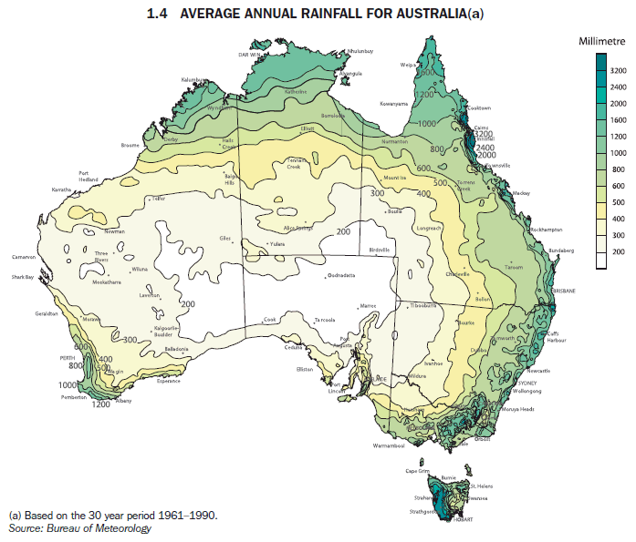
Two-thirds of Australia receives on average less than 350mm (14 inches) of rain a year.
Lake Eyre: average annual rainfall 150mm, average number of days when rain falls per annum 12. Marree: average annual rainfall during the 1990s, 75mm.
We were heading in the direction of those two places. (Marree is the dot in the middle right of South Australia.) I was expecting the landscape to be dominated by dust and sand and the fiercely red rock of the Centre. Like — deleting the vegetation — on the way up or down Mt Ohlssen-Bagge (actually part of Wilpena Pound):
But even further north this rock bank at Arkaroola shows the remnant effects of heavy summer rains (an unusual weather event, climate change). 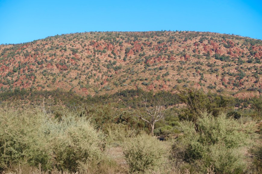
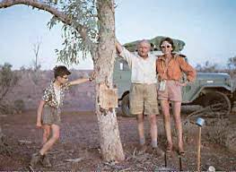
Mulga, spinifex, callitris (native pine), samphire, bluebush, various types of saltbush and cassia spread over the hill, and in the foreground are stands of the abruptly named Dead Finish. Three things, we were told, survive a drought here: euros (a species of small and congenial kangaroo), feral goats and Dead Finish. Dead Finish is a member of the acacia family and up close looks like this. 
Adaptation it’s called.
 I chose the 14 inch isohyet because that’s the measure that George Goyder, South Australia’s Surveyor General in the mid-19th century used to differentiate land suitable for agriculture and, the vast majority, that likely to be subject to drought. Goyder’s Line appears below. We were travelling up and beyond that northern intrusion.
 Goyder was one of those wise people who give you a considered and sensible view, an expert view based on evidence he’d spent nearly three years collecting — and is then ignored. He provided his report in 1865. 1866 and ’67 were unusually wet years and so prospective farmers, intoxicated by the possibilities of new ‘unclaimed’ land, planted crops well north of the line, sure that rain would follow the plough. A Trumpian maxim if ever there was one. Just nuts.
Kanyaka Station was selected in 1852. Two years after, Hugh Proby the English aristocrat responsible, died aged 24 trying to cross the Willochra Creek in a flash flood. On his tombstone a quotation from the gospel according to Mark: Take Ye Heed, Watch and Pray: For Ye Know Not When The Time Is.
Not the time … nor what to do with this land.

The station was sold on and that was when these buildings (the homestead) with stone walls 45cm thick were built. Cattle were replaced by sheep just in time for the 1869 drought when 20,000 starved to death. The 70 families living on the station left, but even so blocks of land were being offered here in 1879 with the suggestion that groundwater was available ‘at very moderate depths’. How many times were stories of this kind to be played out in this country?
Not that far from here European explorer Edward John Eyre, born in very damp and English Bedfordshire, stood on a high point of land looking north out over the vast salt pan he named Lake Torrens and decided so far, no further. ‘The whole was barren and arid-looking in the extreme, and as I gazed on the dismal scene before me I felt assured, I had approached the vast and dreary desert of the interior.’
He called that protuberance Mt Hopeless. This is in a great Australian naming tradition. There are several other Mt Hopelesses. Eyre himself named Mt Deception and Mt Distance. Then there’s Mt Desperation, Mt Disappointment, Mt Despair, Mt Misery (there are five of these in four states), Mt Buggery, Mt Scabby, Mt Isolation, Mt Mistake (several), Mt Failure and Mt Terrible. And that’s just the mountains — which could be expected to be majestic, invigorating! Don’t start on other natural features. I am happy to note that there is one Mt Glorious and one Mt Useful.
This is part of an ongoing story of failure to come to terms with what this country actually is and how it works. I note in passing that the Adnyamathanha, Ngajuri, Nukunu and Barngala peoples had been living here successfully for many thousands of years.
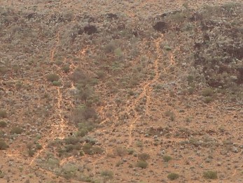 Not a great photo, illustrative only, but these are sheep tracks about latitude 30 degrees south, way north of where I’d say they should be. Such is the fragility of this country — at least to the predations of hooved and two-legged creatures, it is otherwise brilliantly adapted to its climate — they could be 100 years old. They could also be more recent. We did see some sheep near here.
How long does the dry Australian bush take to recover from incursions like this?
In 1855, after and as a consequence of the Eureka uprising, the Victorian government introduced the first formal traces of the White Australia Policy, a head tax of £10 on Chinese immigrants to the colony. (This was a lot; the journey from China would have cost £10-12.) So instead of landing in Victoria, the Chinese landed in South Australia. Between 1857 and 1863 for example, 16,261 Chinese males and one female landed at Robe, occasioning a walk of 500-600km to the gold fields. Others, far fewer, disembarked in Adelaide and followed a path which went through Victoria’s Little Desert. 150 years later, despite not having been used since those times (the Victorian law was soon repealed as ineffectual), the track they took through the Little Desert is still clearly visible.
That’s how long it takes. Forever.
• • • • •
We flew to Adelaide and began by spending a few days there.

This is a good photo for these reasons. It is unexpected. (Two women sitting in an unusual configuration inside an art installation at the Art Gallery of SA. The furry things on the carpet are intended to be read as rabbits. I’m pretty sure.) The very satisfying balance and level of interest of the background items. The faces of the women, directly addressed to the camera, composed and resolute, confident but not noisily so. In it. In the photo.
How they are dressed will tell you a certain amount about a) the weather and b) Adelaide, Melbourne’s doting little sister. Paul Kelly sings:
And the streets are so wide everybody’s inside
Sitting in the same chairs they were sitting in last year
(This is my town!)
All the king’s horses all the king’s men
Wouldn’t drag me back again
To Adelaide Adelaide Adelaide …
 Yeah well. I’ve spent a lot of time in Adelaide and it’s better than that, especially for a visit.
But I know what he means about the streets.
We went the long way north through Clare and its vineyards, going through Yacka with its late afternoon shadows.
On the outskirts of Port Augusta’s excellent Arid Lands Botanical Gardens we stood where it is believed that Matthew Flinders did when he first saw the eponymous ranges. This is the top of Spencer Gulf which wanders off into the desert in a barely defined series of water holes and salt pans. Oddly, they are mangroves in the foreground.

 Flinders was 27 in 1801 when, in command of the British Naval ship Investigator, he surveyed and mapped the entire southern coast of Australia from Cape Leeuwin (the south-western ‘corner’ of WA) to Sydney. In the following two years he circumnavigated the continent in the same boat despite it leaking badly for at least half of this epic journey. They don’t make ’em like that anymore.
He married just before he left on his first voyage intending to take his bride with him, but this was forbidden by the Admiralty. On his planned return home from Sydney his ship failed near French-controlled Mauritius. Suspecting espionage, the Governor detained him on the island. Thus it became nine years between him leaving England and seeing his wife again. 
You will be glad to know she had remained loyal to him and within a year of his return they had a daughter. They really don’t make ’em like that anymore.
It is believed he is buried somewhere under what is now platform 15 of London’s Euston Station. He’s here in bronze, somewhat ill-used, with seagull, outside Melbourne’s St Paul’s cathedral.
Not widely known is his contribution to the naming of Australia, at the time called New South Wales (the east coast) by the English and New Holland (the west coast) by the Dutch and French. I note in passing how very little it is like either South Wales or Holland. Cartographer/ adventure writer Alexander Dalrymple had called it Terra Australis (“the Great South Land’) in a 1771 publication, but Flinders was the first to use the term ‘Australia’ (all in capitals) on a map.
‘There is no probability, that any other detached body of land, of nearly equal extent, will ever be found in a more southern latitude; the name Terra Australis will, therefore, remain descriptive of the geographical importance of this country, and of its situation on the globe: it has antiquity to recommend it; and, having no reference to either of the two claiming nations, appears to be less objectionable than any other which could have been selected. Had I permitted myself any innovation upon the original term, it would have been to convert it into Australia; as being more agreeable to the ear, and an assimilation to the names of the other great portions of the earth.’
Directly influenced by Flinders’ reasoning, Governor Macquarie recommended its use to the British Colonial Office in 1817. Hastening slowly, in 1824, several years after Macquarie had left his post, officials of the Office agreed.
But Flinders didn’t name the ranges after himself. Governor Gawler did so in 1839. Flinders referred to them only as a ‘rugged chain of mountains’. It is unlikely that the Adnyamathanha (‘mountain people’, pron. adya-mar-thayna, usually quickly like a low rumble) would have had a name for the ranges as a whole. They would have been much more particular in their interests. But in deference to their original inhabitants, they are now referred to as ‘Ikara’, Adnyamathanha for ‘meeting place’.
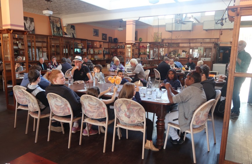
Meeting place — Emily’s Bistro, Quorn. Quorn is one end of the steam train ride which will take you through the Pichi Richi Gap to Port Augusta and back again. This table was on an excursion run by a woman who, on the day, as you can imagine, was very busy. What a good woman. The guy in the hat was more a lingering presence.
• • • • •
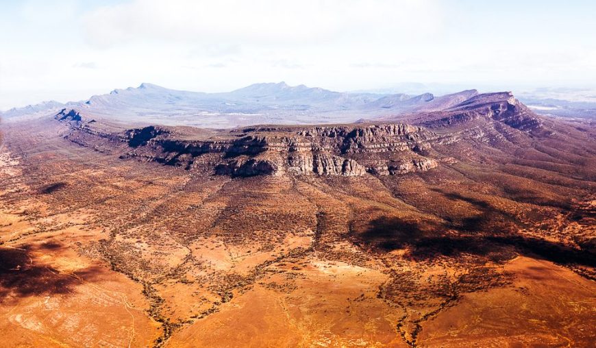
 Two versions of Wilpena Pound. The resort where one stays is on the creek transecting the eastern wall about half way up visible in the overhead aerial photo.

St Mary Peak/ Ngarri Mudlanha circuit. It was an icy morning when we began the walk, about minus five, and sharp on the fingers and nose.
This is where we were heading. It is marked ‘St Mary Peak’ on the aerial photo above.
We had climbed Mt Ohlssen-Bagge (named awkwardly after a business partner of the surveyor’s! So much for local reference) the day before for a bit of acclimatisation and I had been surprised by how verdant the whole area was. Only a bit arid at this time. I was even more surprised on this morning by spending an hour or two walking through a forest of tall callitris, quite obviously on the wet side of the hill.

 This was as easy as it looks, a walk in the park; but we needed to gain about 800m so the climb didn’t start too far away although its early stages were painless. Cup of tea about now and I’ve stripped off to a T-shirt by 10 o’clock. It might have got to about 22 glorious degrees.
 And then it got steeper: sandstone zig-zags, loose rock, smallish grass trees, elegant little bushes with very sharp spines. This is on the way up to Tanderra (‘resting point’) Saddle, the last bit of which requires some hand climbing.

Tracks to peaks like this one are usually constructed with a deviation round to the rear of the scarp with a climb up the tilted slabs which often provide their own interesting labyrinths. That was the case here.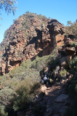
And as is also usually the case, it took 20-30 minutes longer to get to the top than I thought it would. But the views were spreading out and fabulous.

Below, some of the rim of the Pound from the Peak, with Dogs cap, cup of tea and drawing pad.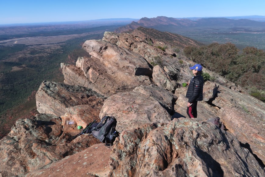
The ranges snake off north in paired sinuous waves. Intoxicating. The Heysen Trail, South Australia’s long distance walk, just visible in this photo, runs down the middle.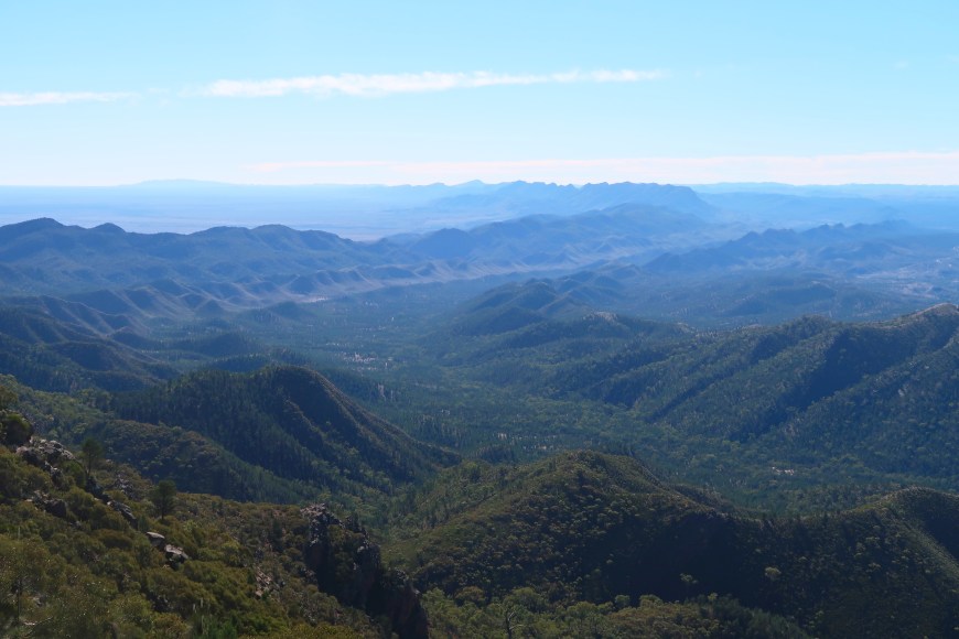
Back the way we came for two km before the descent onto the floor of the Pound. We’d been leap-frogging with a young couple on the way up but the girl rolled her ankle and they had decided to go back the quickest way, so we were probably on our own during this leg.
 Thick casuarina, in places growing across the track, suggested that it wasn’t heavily used and its surface of sharp broken rock the size of tennis balls suggested why, but after four or five km. we got back into another callitris forest with sand (and a couple of blisters) under foot.
A stone garden with callitris in the foreground, river red gums signalling nearby (intermittent) water in the background. Late sun, long shadows. Time to get home. Still six km or so to go.
This is a heavily waymarked walk — they look after you in South Australia — and we were timing our 200m sprints when we were interrupted by Hill’s Homestead and the North Wilpena Creek, almost running, which you accompany for the last few km.
21km, nine hours — and with an hour fooling around and eating and drinking that’s about what it took us. Myrna thinks it could be the best one-day walk she’s ever done.
• • • • •

This is a restored version of the Hill family homestead in its original location. It housed the parents and their nine children. Some of them must surely have slept outdoors. They lived here for five years before even this was built.
Colonists encountered Wilpena Pound in 1850. It was surveyed in the following year and the lease, one of the very first to be issued in this part of South Australia, was taken up that year by the Browne Brothers. The station was established by their partner, twenty-five year old Henry Price, who decided to build the homestead and station headquarters near Wilpena Creek which drains the Pound.
In 1861 Price paid £40,000, a fortune, to become sole owner and manager of the station. At the time of sale its total area was around 2,000 square kilometres (!) and it was carrying more than 17,000 sheep, and 5,000 cattle. Price built that up to more than 33,000 sheep and 4,000 cattle. But after the great drought of the mid 1860s, ‘when not one green thing was left alive’, fewer than 1,000 sheep were left and no cattle.
Owners came and, especially, went — a steady stream of failure — for the next 40 years until 1899 when the Hill family from Hawker took out a lease over the Pound, deciding to try agriculture, something never before attempted so far north. The great drought of the 1880s had proven the validity of Goyder’s Line, and Wilpena is 150km further north. But being in the shadow of some of the highest mountains of the Flinders Ranges, rainfall in the Pound is a little higher.
There is a series of information plaques near the homestead of which my memory is imperfect, but I remember these things.
The conditions the government attached to their lease meant that they were required to run 120,000 sheep on their holding. Insane. But they did, until hit by another drought at the end of which they had fewer than 2,000 left. That was when they decided to turn their hand to wheat. You can still see the area they cleared for this purpose.
But then, besides getting supplies in — they had a struggling vegetable garden, but every other single thing — they had to get their crop to market and the only feasible point of access was along the creek. They spent 11 months constructing a road, a ‘corduroy’ track consisting of logs laid perpendicular to its direction. But they had to get up and over a huge tilted rock slab, called ‘Sliding Rock’ today, which they did by drilling holes and binding their logs to heavy steel pins driven into those holes.
This may be one of those stories — but when they got their wheat to Adelaide (via ship from Port Augusta, after 300km by horse and cart from the Pound), it was believed to be of exceptional quality and some of the best ever produced in the colony.
1912 and 1913 were drought years, but they still managed to get some harvest. Then on Christmas Day 1914 — and I do remember this from the plaques — huge dark clouds gathered and the Pound received rainfall such as European settlers had never experienced. The deluge exited the Pound through the creek gorge and completely destroyed every part of the road they had spent the best part of a year building.
The family left very soon after. For keeps. I wonder how long the discussion went before that decision was made.
• • • • •
 Just thinking about this has brought back a sharp memory from the distant past when I was working pickling wheat near Beulah in the Victorian Mallee region.
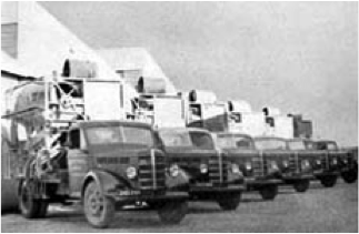
‘Pickling wheat’ at that time, about 45 years ago, meant driving around a war surplus 1940s Chev truck with a Heath Robinson contraption on its back. (That is actually them at left, a pic stolen from the history section of Hannaford’s website. You can find anything on the net.)
You started the machine by hauling on a huge leather belt to turn the stationary engine over. Advanced farmers would pipe the wheat into the hopper through an auger then out the other end straight into a silo, but when I was pickling most farmers would bag in-bag out. You could do about 300 bags on a good day. I developed a huge callus on my right knee from humping bags. And dreaded doing barley. There was no option but to burn or throw away your clothes after 50 bags of barley. The prickling was unbearable.
The process would get rid of chaff, stones and dirt so the seed would run smoothly down the drills when it came to planting. The remaining seed was also covered in ‘pickle’, a dust of copper phosphate as standard, mercury if they wanted to pay more, to keep out rodents, bugs and a number of diseases. Lord knows how much mercury I inhaled. It wasn’t really an Occ health and safety type of job, but for an impecunious student it was very lucrative.
But the point, the point. A company called Hannaford’s, still going, had a monopoly on this process. Their picklers — they preferred young Methodists, and theological students if possible — would be assigned a region where they would do all the farms. I did Murtoa, Beulah and Minyip — all pretty close to the Goyder Line which actually runs through Beulah. It had been a good year, but regardless of what you’ve harvested you still need seed.
The deal was ‘the pickler’ would stay with the farmer where he finished for the day — and this was a sort of highlight for all concerned. In the month or so it took to do a region, ‘the pickler’ would become a figure in the community. I slept in a canopied four-poster bed with silk sheets; I slept in an overturned dunny on a horse hair mattress. Dinner was often a feast, but at least one night it was half a slab of beer. More if you wanted it.
I was 40km or so west of Beulah heading towards the Big Desert country working for two bachelor brothers. They had state of the art machinery and an amazing machinery shed with a full concrete floor in which absolutely any farm engineering task could be accomplished. We finished their wheat, augered from memory, and they carted me off to cut out a sheep and kill it. It was skun and hung for mmm maybe half an hour. The legs were butchered off and cooked in an open fire — which was their kitchen. Quite well-equipped, but most definitely outdoors. That was dinner.
I had mistaken their house for a small derelict wooden shed. They turned out to be one and the same. The boys slept in swags under a nearby tree, and that night I slept in the house in a double bed shared with their 80 year-old mother. I encountered her for the first time as she clambered in. During the course of the night neither of us was molested.
The old days are still pretty current some places.

• • • • •
When you go to the Flinders Ranges you are well advised to keep travelling north to the Gammon and Northern Ranges. It’ll be a dirt road and you won’t have it all to yourself.
But it’s worth it. It’s another sort of country, a geological wonderland. The southern ranges are folded sedimentary layers — the Pound just happened that way, large dimension folding. The northern ranges are all sorts.
The Arkaroola Protection Area, our destination, is the first place radium-rich minerals were discovered in Australia. The overlying layers of sandstone, siltstone and granites are about 1600 million years old making them a billion years older than much of the rest of the rock in the Flinders Ranges. (Ah we toss these terms around as though they are imaginable …) These rocks were impregnated with uranium and thorium. About 440 million years ago (Ma) as these elements decayed they heated the 12km thick rock blanket until it fractured and in sections melted. This happened again around 299 Ma which produced an enormous geyser explosion. These events and their consequences are unique to the area and have left behind an astonishing array of exotic but readily accessible minerals (so to speak).
The camera’s auto controls have taken some of the sting out of it, but this patch of rock was fluorescing so vehemently it was hard to look at in the sunlight without sunglasses.
The ‘township’ of Arkaroola (below) with Griselda Hill immediately behind, has no stable population. 
Even the longer term inhabitants leave in the summer. You see tourists mainly, but first European interest was geological and the settlement retains a scientific flavour. There are two astronomical observatories, a stone wall built to mirror the actual geological form and makeup of its location, and a ‘gem chamber’ with a roof open so that the sun can shine in on the collection of crystals and other rock stars of the mineral world. Above the urinal in the restaurant is a colour chart so that you can assess your degree of dehydration.
I like all that, the assumption you take an intelligent interest in where you are — 610 square kilometres of wilderness sanctuary.
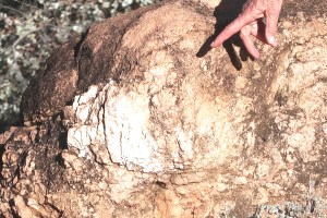
Like further south, the area’s first people are the Adnyamathanha. One of their dreamtime or creation stories says that Arkaroo, a mythical monster, drank Lake Frome dry. He then crawled up into the mountains. When he urinated he created the waterholes that are a feature of the area. His movement over the land created Arkaroola Creek. (A poor photo of a rendering of this story on a cave wall.)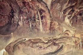
Edward Eyre (in 1840) and George Goyder (1857) were the first Europeans to get this far north. From 1860 to 1863 there was a small failed settlement nearby, at the Yudnamutana copper mine. Drought drove the miners out. Settlement didn’t occur again until 1903, after rubies and sapphires were discovered. In 1910 a copper smelter was built at Yudnamutana and later uranium was discovered nearby by Sir Douglas Mawson, more famous for his explorations in the Antarctic.
The land was always marginal and projects failed quickly. Uranium exploration persisted sporadically and led to the development of a relatively good road in by optimistic companies. In 1935 the Arkaroola property was fenced and an eradication program begun to get rid of the feral donkeys, camels and goats which had done enormous damage to the environment.
 Its contemporary history begins with geologist Reg and Griselda Sprigg (at left with son Doug who still shares the running of the place) purchasing the pastoral lease in 1968. A student of Mawson’s at Adelaide University, Reg had first come to the area on a final year field trip.
After Sprigg had established himself as one of the world’s pre-eminent geologists and had set up his own consulting geological and geophysical companies — involved with Santos, Cooper Basin, Moomba Gas Fields, mining uranium, nickel, copper, petroleum — and, in short, made a lot of money, Mawson asked his former student to do what he could to protect the area, which he thought was the world’s greatest open-air museum of geological history.
When the Arkaroola pastoral lease came up for sale in 1967 Sprigg tried to persuade the SA Govt to purchase the property and declare it a National Park. But they felt it too remote, and finally said if he felt so strongly about it he should buy it himself — which he and his wife Griselda did in 1968. Reg decided it best to open it up to tourists and use the profits to fund environmental projects. As it turned out the Government had been correct. It was a long way for visitors to come, and they came in small numbers. So most of the funding for buildings, tracks, other infrastructure and conservation came from the Sprigg family.
47 years on, the native flora and fauna are in excellent health and the majority of the property remains weed free. One species under threat was yellow-footed rock wallabies. We saw dozens of them, most elegant creatures.
Just before we were there Arkaroola had been visited by representatives of the World Heritage Commission. It was whispered that their off-the-record briefing suggested that the WHC could never hope to be as well-versed about the property as the incumbents and would simply be intrusive and a nuisance. It would be better looked after with the present regime maintained.
It has three zones: the Mawson Plateau Wilderness Zone (no tracks/no vehicle access); the Ridgetop Zone (one track only with locked gates; used only by Arkaroola vehicles), and the Multi-use Zone. Walkers have access to the whole property. And we walked through this amazing country.

We did three half-day walks which could be hooked up. Mawson Valley/ Spriggina provides a useful introduction. Flora, fauna, geology — wonderful. 
You can see clumps of spinifex on the incline to the right of the track. Sturt’s Desert Rose at left.
 An ant feasting on Curly Mallee flowers.
We followed this with a walk along Acacia Ridge full of glorious views, the buildings of the resort at mid-left.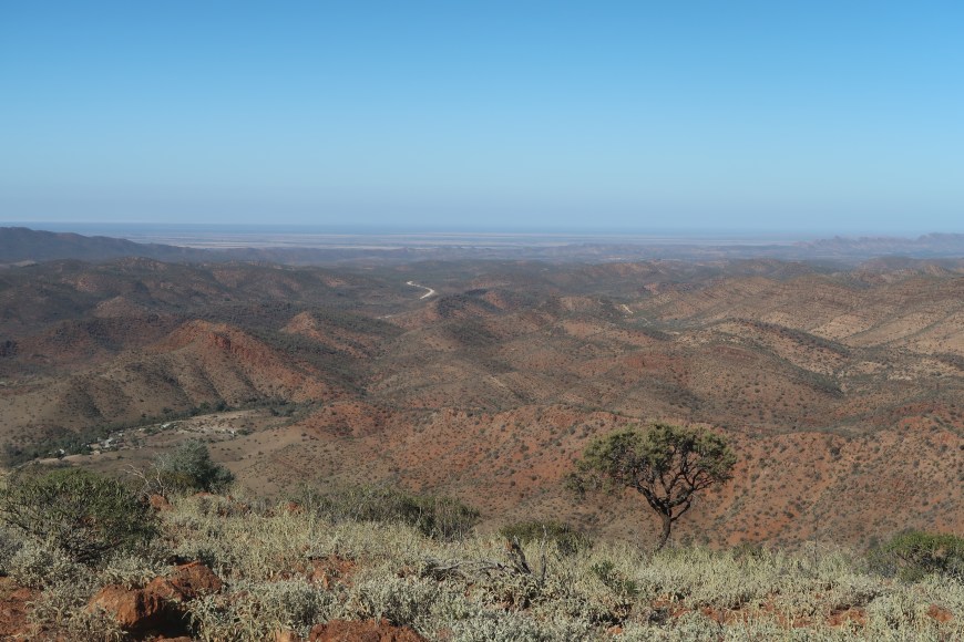
But the best walk was Barraranna Gorge:  weird rock strata,
  tillite (‘foreign’ rocks as big as a football embedded in the background material)
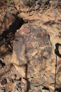 and dramatic rock pools in sumptuously coloured settings.
You need to go on the Ridge Top Tour which provides AWD access to one of the sections of the preserve otherwise off limits. And what ride it is. When you don’t think you’re going to tip off the track you are aware of this heart-palpitating scenery. The highlight, and furthest point, is Siller’s Lookout. Access to it looks like this.
And yes there was another vehicle up there, the usual tour ‘bus’ with a cracked differential housing. The plan was to drain and flush the differential and then weld the crack sufficiently to get the truck back. Not a job I’d like. Myrna preferred to walk as I tried to take a photo of what it felt like.
We might have been paying for thrills and spills but we got as well a very fine lecture on the history and geology of the area and views like this. Broken Hill is about 400km somewhere over there.

• • • • •
Copley is where you get back on the bitumen, but Leigh Creek is only five km away.

 Leigh Creek is a government-owned town on the edge of the desert (annual average rainfall: 205 mm). It is for sale as its original purpose, to house the workers and their families who provided the labour force for the Leigh Creek open cut coal mine 22 km north of the town, ceased to exist when the mine was closed in 2015. At the time Leigh Creek was a ‘modern’ (I quote) mining town with a ‘modern’ shopping centre, a series of neat ‘modern’ roads and small, attractive plots of land on which standard ‘modern’ houses had been built. (Nothing is ‘modern’ these days. ‘Modern’ has come to mean slightly outmoded.)
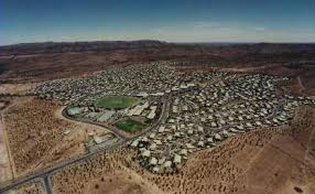
And there it is, just plonked by the side of the Outback Highway with its lush green oval and its big school and its shopping centre and its population of 125, down from 2500 at its peak in 1987.

Leigh Creek Area School (pictured, with lone student), 560km north of Adelaide, is in the hot arid zone of South Australia’s northern Flinders Ranges. Our students come from Nepabunna, Iga Warta, Copley, Lyndhurst, Beltana, Leigh Creek and station properties. That’s how Leigh Creek’s entry on the MySchool website begins.
It goes on: The closure of the mine and reduced numbers have taken an emotional toll on students, staff and community. The grieving process continues as, on a daily basis, people are losing friends and services within the town. On top of this families are dealing with job losses, unemployment and uncertainty about the future and how to make transitions. The site improvement plan placed an emphasis on improving student well-being. As the year has progressed we have also worked towards development of improved social skills that enable students to build new social groups as old ones disintegrate. Our aim has been to keep the school as a secure part of students’ lives and of the town.
What will happen here? Who will want to teach in a school in such obvious decline (and not of its own making). 96% of families in the bottom SES quartile, just under 50% Aboriginal: they’re not the reasons why it’s in decline but they are additional reasons why it might be very hard work.
 Most of the current working population is engaged in the recovery and rehabilitation of the mine site. One aspect of this process is to diminish the prospect of spontaneous combustion. (!)
This photo from the official closure document illustrates the relative sizes of the mine and the township. Also pictured bottom left looking like small black snake is Lake Aroona which was disappearing not just because of the minimal rainfall but the silting occurring as a result of the degradation of its surrounds.
This has now been managed and improved to the point where it has become a model for other reclamation processes.
The closure of the mine is not a concern for grief. Originally its purpose was to make South Australia self-sufficient in energy production, but the coal was of such poor quality that the plant where it was burnt in Port Augusta had to be specially modified to accommodate its inadequacy. Massive new solar farms are being built in hot and dry South Australia and this site itself is being tested for possible methane production.
We come. We go. And then there is what we leave behind …
• • • • •
Finally, a few words from Don Watson’s book ‘The Bush’ (which should be learnt by heart by every Australian child):
Close, even cursory, examination might reveal that the bush is not a dangerous neurotic, that drought and all the other defects in the country are really defects in our thinking, and even that mateship, which is built and exercised less on our love of the bush than our fight with it, is half humbug and baloney. In this case our mental slate will be that much cleaner. While we’re at it, we might as well own up to the carnage: a bit of truth and reconciliation will help us to grow up. Then, denatured though we are, we might work out what we owe the bush, what we want from it, and what is reasonable to ask from it. It’s not just food and wealth, marketing icons, and movies about bush-nurtured sociopaths and felons: we need to do more than leverage our vast and marvellous estate. Much better to know it and ourselves.
